West End Point Outlook - Watch birds, the sea and the sunset looking towards Little Cayman.
Westerly Ponds - On the southwest shore, use boardwalks and viewing areas to observe over 100 species of birds on the wetlands.
Walk to Windlass of S. S. Kearsarge - Pass the airport entrance and continue on West End Road, turn right into James Scott Road, cross Georgiana Drive to the sea. The windlass (1860 ship's winch) lies on the Ironshore to your right. To complete a loop walk, follow signs east along the shore and return to the main road by Robert Foster Lane. Swimming at Buccaneer Barcadere (Beware, sharp drop off).
M/V Capt. K.P. Tibbetts - Also known as the Russian Destroyer, this now famous dive site bears the name of a notorious Caymanian whose life was dedicated to the islands and its-well being. He has been recognised by many organisations before and after his death.
Cayman Brac Community Park - On West End Road west of the airport. Great for picnics and short walks among the woodland.
Pioneer Walk - Loop walk at the West End. Follow Pioneer Lane to the sea, there is a sandy beach to the west or turn east along a hurricane boulder path and return on the track to the main road; birdwatching. One hour.
Mass grave site - At least 19 people are buried here , all drowned in one house during the hurricane on 8-9 Nov 1932, the worst to hit Cayman Brac in the 20th century.
National Trust HQ - On White Bay Road, near the sea. Shop and interpretative centre. You can also visit a mass gravesite from the 1932 hurricane, which is close by.
Salt Water Pond Walk - A trail (# 11 in reverse) running from the north coast at White Bay to the south coast. The trail is very rough and still being developed, only suitable for experienced hikers.
Salt Water Pond - A Sanctuary at the junction of South Side Road and Gerrard Smith Road; seasonal birdwatching. Least Tern colony, April-August.
Salt Water Pond Walk - A hike from the south to the north coast, beside Rebecca's Cave; birdwatching and tropical plants. The trail is very rough and still being developed, only suitable for experienced hikers.
To Rebecca's Cave/ Salt Water Pond Walk - Follow sign on Rebecca's Road at junction with South Side Road to get to this trail.
Rebecca's Cave Historic site - the cave was once used as a hurricane shelter.
The Marshes Wetlands on South Side Road - near the Public Beach; Enjoy birdwatching and see Red Shrimp Hole.
Stake Bay Walk - Take Ryan's Drive to Stake Bay Rd., see the Ryan cemetery, schooner launching ramp and dock, the historic Kirkconnell house. Return via Kirkconnell Street and visit the Museum (#16) on the main road.
Cayman Brac Museum, Stake Bay - Monday through Friday 9am to 12noon and 1pm to 4pm; Saturday 9am to 12noon.
Deadman's Point Bluff Road - A trail (#18 in reverse direction), from Songbird Drive to north coast. At bluff, exit on Songbird Drive follow signs to Hemmington Road and complete hike to north coast on second trail (#22 below). Return 2.5 hours.
Deadman's Point Bluff Road - Climb the bluff steps on the north coast (east of the Museum) to hike through endemic forest to Songbird Drive (Stake Bay Bluff Road east); see endemic birds and plants. Return 1.5 hours.
Half Way Ground Cave - See this cave from the north coast, east of Hemmington Road.
Hemmington Road - Climb the bluff steps on the north coast, east of Deadman's Point Bluff Road; hike through endemic forest to Songbird Drive (Stake Bay Bluff Road East); see endemic birds and plants. Return 1.5 hours.
Bats Cave - Visit this deep cave with several chambers on South Side Road.
Hemmington Road - A forest trail (as # 20 in reverse direction) from Songbird Drive to north coast.
Bight Road (north) - Climb the steps to the bluff on the north coast, east of Ashton Reid Drive; hike through ancient forest along the boundary of the Parrot Reserve to Major Donald Drive on the mid bluff; see endemic birds and plants. Return 1.5 hours.
Bight Road (north) - a hike through forest (as # 23 in reverse direction) from Major Donald Drive to the north coast. Return 1.5 hours.
Bight Road (south) - Hike from Major Donald Drive to the south bluff edge and panoramic views. Return 1.5 hours. Return hike from north to south coast, 3 hours.
National Trust Nature Trail - A short hike off Bight Road south; see birds and endemic plants including orchids.
Heritage House - In the grounds of the Lazzari home, gardens, and old tannery at Northeast Bay. Information on tours, guiding, nature trails and historic sites, slide shows and cultural events. Steps up to the bluff and a path along bluff foothills.
Big Channel Road Outlook - Climb the historic steps up the north face of the bluff, west of Spot Bay. Follow path from main road to enjoy panoramic views of the island.
Peter's Cave - The traditional hurricane shelter for residents of Spot Bay, on Lighthouse Steps. Access also from top of the bluff via path from Peter's Road car park.
Lighthouse Steps - In Spot Bay, follow signs on Lighthouse Road to the historic steps up the northeast face of the bluff. Return hike to the Lighthouse on the eastern bluff, 3 hours minimum.
Peter's Outlook - Panoramic view of Spot Bay, at the top of the Steps. Access on top of the bluff from Peter's Road car park.
Spot Bay Community Park - Perfect for a beach picnic and swimming (Beware of sharp drop off).
Lighthouse Footpath - Get to the Footpath via the
Lighthouse Steps, past Peter's Road car park on
the bluff to Footpath entrance gate. Hike
through shrubland onto a wide path close to the
bluff edge to the Lighthouse. From here you can
appreciate panoramic views, endemic vegetation
and seabirds. Visitors are strongly urged to stay
on the trail for both your hiking safety and the
safety of the birds who live there! Return, 3 hours-
stout shoes and water are essential!
Long Beach - Follow the path to the shore through seagrape at the east end of the north coast road- you'll find a dramatic walk below the bluff. Climbers only can continue further east- beware of rough seas! Return to the end of the beach, 1.5 hours.
Beach walk to First Cay - A robust walk from the end of the road along the southeast shore below the bluff to the large rock (First Cay); only serious climbers should proceed further as rough seas are a hazard. View the Brown Booby, Frigatebirds, and migrant Tropicbirds from January to August. Return trip 2 hours.
Little Cayman Brac Outlook - Overlook the cay (large rock) half way along the Lighthouse Footpath. Brown Booby breed in caves and ledges in the bluff below. Take care!
Lighthouse - The old beacon dates from the 1930's. Operational lighthouse.
Christopher Columbus Gardens - Located on the majestic Bluff the park was the vision of the Cayman Brac Quincentennial Committee and is the home of the Wall of Honour which lists 500 names of past and present prominent people in the community who "contributed significantly to the development of the Sister Islands over the past 500 years" and a relief of Christopher Columbus.
There are also several boardwalks and a gazebo constructed to fit in with the natural surrounding environment. The beautiful floral adds a special touch to this magnificent location.
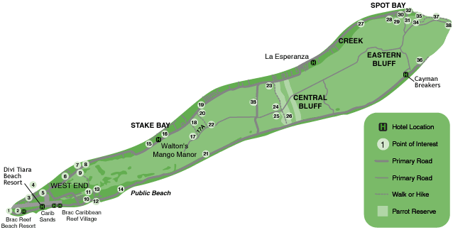
Explore all that Cayman Brac has to offer - roll over each of the numbered circles on the map below to learn about the island.
Brac Facts
Hot Spots and Natural & Historic Attractions