Historic Caymanian houses and Graveyard. Walk along a village street that has changed little in 60 years. In the graveyard many
of the headstones tell of the earliest settlers to Little Cayman.
Village Square. Shops, bank, gas
Neptune's Berth Condominiums.
Little Cayman Museum. Opening hours Mon, Wed, Thurs, Fri 3-5pm.
Old Baptist Church. Built first in 1887, destroyed in the 1932 hurricane and rebuilt.
National Trust House. Information centre, library, gifts; viewing platforms, telescopes and interpretative signs on the red-footed
booby and magnificent frigatebird colonies and waterbirds. Photography. Opening hours Mon-Sat 3-5pm.
Booby Pond. Colony of 20,000 red-footed booby(the largest in the Caribbean) and 350 magnificent frigatebirds; major breeding and
overwintering site for herons, shorebirds, waders and ducks, including the endemic West Indian whistling duck. Owned and protected
by the National Trust, and a Ramsar site, a wetland of international importance.
Bird Outlook on Booby Pond. Opposite Southern Cross Club; excellent for evening bird viewing and photography.
Little Cayman Beach Resort. Booby Pond viewing area.
The Club Condominiums & Miss Rilly's Back Porch Restaurant.
Conch Club Condominiums.
Southern Cross Club Diving & Fishing Resort.
South Hole Sound. Swimming, sailing, snorkelling, fly fishing, shore walks, and good bird watching on the shore and fringing reef.
Owen Island. Scenic cay on the southern edge of the South Hole Sound Reef. Swimming, picnics, tropical plants, shorebirds and seabirds.
Kingston Bight Lodge & Restaurant. Resident and migrant landbirds in the shrubland and forest. Olivine Kirk Drive, Guy Banks Road,
Spot Bay Road
Tarpon Lake. Boat dock, tarpon fishing and bird watching: waterbirds around the lake and landbirds, especially migrant warblers in
the mangrove forest close to the road.
South Coast. Shore walks, seabirds, fly fishing. Charles Bight Rosetta Flats.
Coot Marsh. Herbaceous freshwater wetland, seasonal bird watching, look for unusual migrants. Cotton plants flower profusely
in spring.
Sandy Point Pond. Bird watching, sunset views and photography.
Muddy Foots. Named after Governor Modyford of Jamaica, 1660s-1670s.
Point of Sand, Swimming, snorkelling, beach picnics, view of Cayman Brac. Beware the current at the reef mouth. Eastern bluff.
East End Point Lighthouse. Eastern bluff, Cayman Brac and sunrise viewing area, endemic plants.
Sink Holes Viewing Area. Panoramic views over the endemic xeric shrubland of the eastern bluff explained in an interpretative
sign. Photography. Walking inland on the karstic limestone is not recommended. North Coast Road, Mary's Bay.
Grape Tree Ponds. Viewing platform and bird watching, especially West Indian whistling-duck, on extended mangrove wetland;shore walks. Photography.
Jackson's Pond. Large mangrove fringed pond, viewing area allows excellent bird watching of herons, ducks, rails, stilt, plovers and sandpipers. Photography.
Jackson's Point Beach. Path opposite Olivine Kirk Drive. Mini-wall is 50 yards from shore; the drop-off(wall) is a further 100
yards for shore dives and snorkelling. Must be a strong swimmer; use a dive flag, booties and fins. Do not attempt when the sea
is rough.
Bloody Bay. Landbirds in the coastal mahogany forest. The drop-off (wall) is closest to the shore here, but shore divers and
snorkelers must first swim through the fringe reef. Get local orientation on how to return to the shore through the reef. Must be
a strong swimmer; use dive flag, booties and fins. Do not attempt when sea is rough.
Spot Bay Pond. Viewing area; West Indian whistling-duck breed here and feed on the pond at dusk.
Sam McCoy's Diving &Fishing Lodge. Good nature and bird watching. Gas available.
Mule Pens. Wailed enclosure built in the late 1800s, used to corral mules that pulled phosphate-laden box cars on a narrow gauge
railway to the Salt Rock dock.
Salt Rock Dock. Deep water harbour, first used by sailing schooners from the 1800s. Swimming not recommended.
Salt Rocks Nature Trail. This historic right-of-way was the footpath from Blossom Village to the Salt Rocks dock from the 1840s.
Entrance/exit at Salt-Rocks/Spot Bay Road. Excellent for endemic and migrant landbirds, reptiles including iguana, butterflies and
moths, tropical plants including orchids and bromeliads.
West End Lighthouse. Sunset views; arrival point for migrant shorebirds; boobies and frigatebirds feed offshore.
Lighthouse Point Condominiums and Sunset Point Villas.
Mahogany Estates. Iguana are often seen on the road. Resident and migrant landbirds in the forest.
Westerly Ponds. Several roadside viewing areas of wetland ponds and temporary pools on Ironshore pavement. Good for herons and
rare waterbirds, and neotropical migrant landbirds (especially warblers) in the surrounding shrubland.
Pirate's Point Resort Ltd.
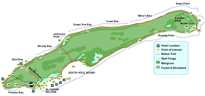
Explore all that Little Cayman has to offer - roll over each of the numbered circles on the map below to learn about the island.